This will be the first in a series of four articles which document the waterways that occur throughout the city of Fullerton, in order to enhance public knowledge of their existence as well as the uses they provide to local residents.
As author Bernard Levin commented about rivers, “And when river and city meet, the human race puts down roots of civilization; it is my consciousness of that truth that makes it impossible for me to get used to the idea of invisible rivers, those streams that have been covered over as cities spread but continue to flow silently and unseen beneath the streets.”
Every great city contains a great waterway running through it; Paris has the Seine; London, the Thames; New York the Hudson; New Orleans the Mississippi; Fullerton, Fullerton Creek.
Huh? Fullerton Creek? What’s that? Where does it go, a Fullerton resident might ask?
Fullerton has indeed lent its name to an approximately 13.5-mile waterway that transverses the City, along with neighboring Brea, Buena Park, and La Palma. Like all of Fullerton’s waterways, Fullerton Creek drains into Coyote Creek and forms part of the San Gabriel River watershed.

The path of Fullerton Creek.
The scene of the creek’s source is quite humble, a feature shared even with the world’s mightiest rivers (such as the Amazon), emerging from underground in a Brea industrial park along Orbiter St., close to the Puente Hills. Upon seeing this, an observer may not give this channel any second thought.

At the source of Fullerton Creek.
Even as the creek, a concrete channel that flows westward in this area, passes by businesses such as the world headquarters of Beckman Coulter, it serves as an unlikely wildlife corridor, hosting multiple pairs of mallard ducks as well as a snowy egret in pursuit of its next meal.

The creek serves as an unlikely wildlife corridor.
The creek then turns southward once it crosses Associated Rd., paralleling the street southwards until entering Craig Park, where it could be said that, similar to a rebellious teenager “finding themselves,” its ‘wild phase’ truly begins, turning into a natural creek that frequently bubbles and rushes and is studded with vegetation, seemingly an act of defiance in the middle of urbanized Southern California.

The Creek flowing through Craig Park.
This section provides many residents of north Orange County with critical recreational opportunities, including walking and jogging trails, hiking, and even fishing, as local resident Anthony Yang can attest. Yang, who frequents Craig Park about once a month, states that he often finds introduced species such as carp, green sunfish, and Texas cichlids within the creek’s banks. “It’s a nice place,” he said, making sure to add that he always catches and releases while fishing.

Yang shows a fish he has caught at Craig Park.
Yang’s fishing session continues a millennia-old tradition. Prior to European colonization of this area more than two centuries ago, the indigenous Tongva/Kizh people of Southern California regularly fished from local creeks either with lines with hooks made from bones or shell, or through the use of nets.
Fullerton Creek appears to end its run at Craig Park at the Fullerton Dam, another WPA project created in order to curb any potential flooding in the local area. If one would like to check out Fullerton Dam, they would unfortunately be out of luck; the dam is currently closed to the public.

However, the creek’s ‘wild character’ continues even after the Fullerton Dam, flowing through a deep ravine behind Marshall B. Ketchum University, and its recreational opportunities soon resume with a nearby hiking trail as it goes through the seven-acre Fullerton Creek Greenbelt and Acacia Park.


The Creek runs through the seven-acre Fullerton Creek Greenbelt and Acacia Park.

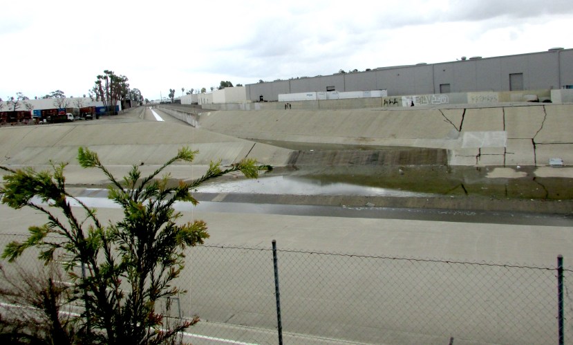
After leaving Acacia Park, Fullerton Creek is “re-tamed” into an urban, concrete channel and changes its direction back to westward, passing near numerous schools, businesses, and shopping centers as it meanders throughout north Orange County. Although not the most glamorous, the concrete channel is a result of flood control efforts undertaken by the Works Progress Administration (WPA) in the 1930s and 1940s in the wake of a damaging 1938 flood, as documented by The Observer last year.
Fullerton Creek’s ending, or mouth, is quite anti-climactic, at Coyote Creek, a large concrete channel again mostly surrounded by industrial buildings. Here, the only eye-popping features are the graffiti written on the creek’s concrete walls.


However, even this section of the creek may have the potential to be used as a recreational community space. Perhaps Orange County and its cities could take a page from Los Angeles, whose current plans to revitalize its own concrete-encased river include a series of parks and trails without increasing any future risk of flooding. This would allow Fullerton Creek to play a more active role in the City’s fabric and communal life.
Share this:

Discover more from Fullerton Observer
Subscribe to get the latest posts sent to your email.
Categories: Uncategorized


Me and two friends rode our bicycles from Acacia park to somewhere in Anaheim that enabled us to get our bicycles out of the flood control channel, in 1983 or 1984. Might’ve been 1985 but it was probably 1983. We traversed the long tunnel of Fullerton creek going underneath Chapman Ave/Alpha Beta parking lot/Raymond Ave without flashlights or bicycle lights, coming out again on the other side of Wilshire Ave behind Alta Dena. That was the high point of that trip.